INTERRISK ASIA
(THAILAND) CO., LTD.
การสำรวจโรงงาน
การอบรมและสัมมนา
การให้ให้คำปรึกษา


[Summary]
▪ In Myanmar, flood risk is highest from July to September as main rainy season.
▪ The frequency of cyclones in the Bay of Bengal increases from June to October, with a peak in July to September. Historically, most cyclones in Myanmar landfall before/after rainy season, therefore it is necessary to monitor and prepare for strong wind and storm surge disasters during April-May and October-December.
▪ Cyclone Nargis in May 2008 was the most severe cyclone in Myanmar’s history. The storm surge, with a maximum tide level of 7m caused severe damage and resulted in the tragic loss of over 80,000 lives.
▪ Many meteorological departments in global have predicted the occurrence of La Nina event later 2024. La Nina often brings heavy rainfall situation to Southeast Asia including Myanmar. It is necessary to prepare for flood risk possibility from more heavy rain disasters during 2024 rainy season.
Seasons in Myanmar are roughly divided into 3 seasons: the dry season from late October to March, the extremely hot season in April and May, and the rainy season from mid-June to mid-October. From June to September, the southwest monsoon, which blows in humid and warm winds, causes high temperatures and humidity, and heavy rain and thunderstorm are likely to occur. From December to April, the northeast monsoon causes relatively cool weather.
The figure below shows the annual calendar of natural disaster hazards provided by the Department of Meteorology and Hydrology in Myanmar (DMH). Special warning periods include the Thunderstorm from March to October, the Heavy rain from May to September, the Flood from June to October, the Cyclones from April to May and October to November, and the Strong winds and Heavy rain from Monsoon depression from May to September.

The cyclone is a tropical cyclone that occurs in the northern Indian Ocean, southern Indian Ocean and southern Pacific Ocean. In the North Indian Ocean region including Myanmar, cyclones are classified according to the maximum wind speed as table below. The following terms are used in the announcement document of India Meteorological Department and DMH. In the Bay of Bengal part of North Indian Ocean facing Myanmar, when the maximum wind speed is less than 34 kt (knots, 1 knot is about 0.5144 m/s), it is classified as the Depression [D] or the Deep Depression [DD], and when it is 34 kt or more, it is classified as the Cyclonic Storm [CS]. Normally, when a cyclone reaches CS level or above, caution is required against violent winds and storm surges.

The table below shows the number of landfalls of cyclones in the Bay of Bengal with a strength of CS or above by country from 2014 to 2023. On average, near 3 cyclones occur in the Bay of Bengal per year. Cyclones tend to move from east to west or from south to north, and they frequently land or approach India, Sri Lanka, and Bangladesh. In the past 10 years, there have been 2 landfalls along the coast of Myanmar, in 2017, 2023.

According to the long-term statistical data (119 years up to 2005) of DMH, cyclones in Myanmar mainly make landfall in April-May and October-December, which are before/after the rainy season. In the Bay of Bengal, about 10 cyclones including depression-level tropical cyclones occur annually, and the frequency of cyclone occurrence increases mainly from May to December. However, cyclones with strong intensity never made landfall in the Bay of Bengal from June to September after the start of the rainy season.


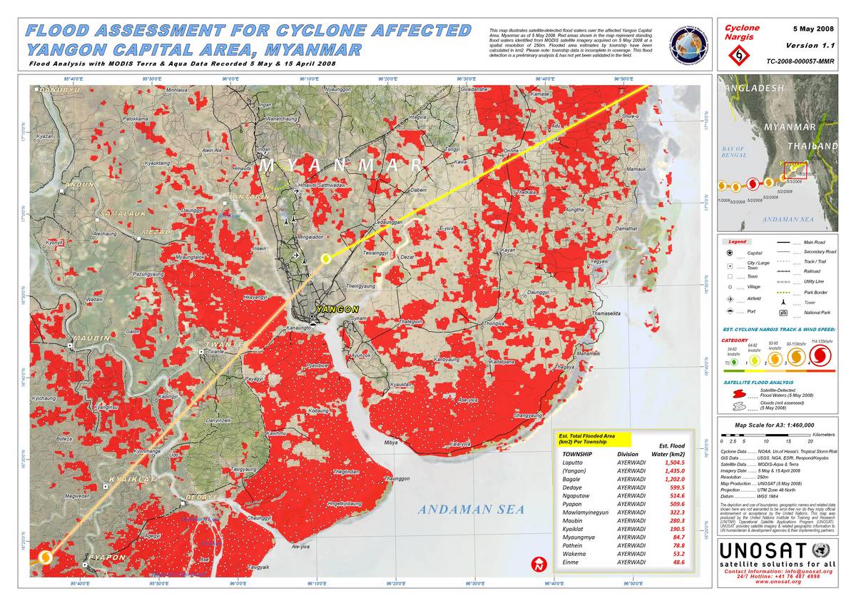
Cyclone damage in Myanmar is characterized by storm and heavy rain, as well as frequent storm surge damage. The most severe cyclone in the past was Cyclone Nargis in May 2008, which caused severe storm surge damage. Cyclone Nargis occurred in the central part of the Bay of Bengal on April 27, 2008. It initially headed toward India, but then suddenly changed its course to the east. Cyclone Nargis made landfall in the Ayeyarwaddy River Delta in Myanmar on May 2, and disappeared near the border between Myanmar and Thailand the next day. The coastal area where Nargis made landfall and the Ayeyarwaddy River Delta are topographic conditions that cover a wide area of low-lying land with a small difference in elevation from sea level. Conditions such as the cyclone’s wind direction, air pressure, and path influenced the occurrence of storm surge damage. This resulted in serious storm surge damage, the worst ever recorded from a cyclone in Myanmar. There are records that the storm surge water level is 3-4 m in the main basin of the Yangon River, and the maximum is over 7 m. In recent years, major cyclones that caused severe damage in Myanmar occurred in 1968 (over 1,000 deaths) and 1975 (over 300 deaths). However, the number of deaths caused by Nargis is an unprecedented over 80,000.
Myanmar area has a high rainfall due to its monsoon climate, and floods occur almost every year during the rainy season. The table below shows the monthly numbers and proportion of major flood events that occurred between 1997 and 2007, according to DMH the table below shows that floods were concentrated from June to October, especially from July to August.

According to statistics from DMH, the Sagaing Region in northern Myanmar has experienced about half of all floods in the past in Myanmar. The Yangon and Mandalay Regions have also had a relatively high number of flood events. Additionally, flood has been reported in Kachin, Bago, Mon, Kayin, and Rakhine States.

The figure below is a hazard map created through a joint project by UN agencies. In the vicinity of Yangon, the low-lying delta area along the lower stream of Ayeyarwaddy River is particularly vulnerable to flood and storm surge. While most flooding in the area is caused by river overflow, severe damage was inflicted by storm surge during Cyclone Nargis in 2008. In the Yangon Region, almost all areas except for inside of Yangon city and northern parts of Yangon are exposed to flood hazards. Specifically, many areas along the Yangon River and near its mouth of the river have experienced frequent flood events in the past.

Many meteorological departments in global have predicted the La Nina event later 2024. The El Nino/La Nina are phenomena in which sea surface temperatures in the central and eastern equatorial Pacific Ocean area continue to be higher or lower than normal for several months to a year. Some meteorological departments in global monitor the sea surface temperatures in the region, and the National Oceanic and Atmospheric Administration (NOAA) in US calls the El Nino when the three-month average sea surface temperature is 0.5°C above normal, and the La Nina when it is 0.5°C below normal. The case where neither is the case is called the Neutral state.
The El Nino and La Nina are thought to be one of the causes of extreme weather in global. In Southeast Asia, such as Myanmar, the El Nino period tends to be dryer with higher temperatures and less rainfall than usual, while the La Nina period tends to have lower temperatures and more rainfall than usual.
NOAA predicts that the current El Niño is weakening and moving toward neutral, and that a La Niña is likely to develop later this year. Meteorological departments in Thailand, Japan, Australia, and other countries have also announced similar forecasts. According to NOAA’s latest forecast in June, the average sea surface temperature from June to August is most likely to be neutral, but there is a 65% chance that La Nina will occur from July to September, additionally at least will continue until the beginning of next year.

The above situation suggests that the La Nina may develop during 2024 rainy season, resulting in a heavier rainfall than usual. And, according to DMH’s latest forecast in 28 June for the mid monsoon period (July-August), rain or thundershower will be expected above normal in Lower Sagaing, Mandalay, Magway Regions and (Southern and Eastern) Shan State and about normal in others region including Yangon.
It is important for companies to aware the latest status of flood risks and countermeasures in normal phase, and to confirm and strengthen responses before/after floods by reviewing plans and conducting drills.
Please refer to the following page for examples of responses by phase normal and before/after flood and cyclone, and examples of risk checklist.

_______________________________________________________________________